

Watertrack-ECO app for iPhone and iPad
Developer: Sven Krzizek-Köchel
First release : 14 Jan 2015
App size: 65.73 Mb
Watertrack in the broadest sense, a comfortable multilingual plotter (currently German & English) for inland waterways in Germany (and partly Coast). Water Track offers already in the ECO version quite a few useful features and information.
Watertrack is also diplaying in Portrait and Landscape Mode (both and automatic)
The manual for our apps, please visit our website. There are detailed videos listed for use!
Watertrack runs from the I-Phone 4s and from I-Pad2 3G up to date equipment.
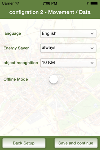
Watertrack is available in German and English and can be changed in the menu!
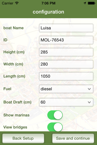
You give your boat a data only once and can then drive off without any further settings. Once set makes Watertrack the rest and you can travel relaxed.
Watertrack runs continuously in the background, as long as you do not stop it, you can use other apps and parallel calls.
Features:
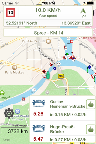
The Head Display (Upper Display) provides information about the currently permitted speed (with warning if you are driving too fast!) And the actual speed. There is a display of coordinates (LAT / LON) your current position and a compass (direction indicator).
This information is updated constantly and serve the skipper as a standard tool.
Watertrack uses the latest maps and overlays - including from OpenStreetMap and OpenSeaMap for the representation of the district in which you are traveling.In the next update without any connection to the Internet or a mobile network provider - you are totally independent of the application.
Watertrack informed you about the following events (selectable, can be disabled):
Bridges - and their heights (you will receive a warning if your boat does not fit under the bridge).
Locks - When approaching you receive all relevant information on the lock (dimensions, telephone).
Ports/Harbours - When approaching you get all the relevant information about the Ports & Marinas (name, telephone).
Speed Limit - Permanent adjustment of the allowed speed on your location.
Water Information and KM xx (name of the water body, river position). Absolute orientation - If you turn your boat, the map turns too.
Note: Watertrack is not a substitute for their recognized or mandatory means of navigation. Watertrack serves only as additional navigational aid and is not a full-fledged navigation with 100% safety on the water.
Watertrack can be used for this rivers and Waters:
- Berliner und Potsdamer Gewässer
- Brandenburger Seen Gewässer
- Mecklenburgische Seenplatte
- Müritz
- Wannsee
- Werbellinsee
- Bodensee, Seerhein
- Dahme
- Donau
- Dortmund-Ems-Kanal
- Elbe
- Elbe-Havel-Kanal
- Elbe-Lübeck-Kanal
- Elbe-Seiten-Kanal
- Elde
- Elde-Kanal
- Finowkanal
- Havel
- Havel-Oder-Wasserstraße
- Havelkanal
- Landwehrkanal
- Löcknitz
- Main
- Main-Donau-Kanal
- Mittellandkanal
- Mosel
- Müggelspree
- Müritz-Elde-Wasserstraße
- Müritz-Havel-Wasserstraße
- Neckar
- Nord-Ostsee-Kanal
- Oder
- Oder-Spree-Kanal
- Peene
- Rhein
- Rhein-Herne-Kanal
- Rheinsberger Gewässer
- Rüdersdorfer Gewässer
- Ruhr
- Saale
- Saar
- Schlei
- Teltowkanal
- Teupitzer Gewässer
- Untere Havelwasserstraße
- Wesel-Datteln-Kanal
- Weser
- Westoder
- Zechliner Gewässer
There are no water depths on the app available. But Water Track offers this in later Updates with OpenSeaMap Layers for water Deepth.
The display of speed with warning of transgression and river names and river kilometers is available.
With WiFi I-Pads unsubsidized for indicating the position outside cities a possible external GPS Receiver is required.
The use of GPS running in the background can decrease the battery life significantly. If your Boat has Power Connect for USB and your Device, it shouldt be no Problem in all.